Showing 23 items matching structural engineer
-
 Whitehorse Historical Society Inc.
Article, Public enjoys fruit of volunteer's foresight, 2001
... was as structural engineer of the design team for Canberra's new Parliament... career highlight was as structural engineer of the design team.... His engineering career highlight was as structural engineer ...Ronald Thyer has been awarded the medal of the Order of Australia for his conservation efforts.Ronald Thyer has been awarded the medal of the Order of Australia for his conservation efforts. He played a major role in persuading Nunawading Council to buy the first parcel of land for Blackburn Lake Sanctuary in the early 1970's. His engineering career highlight was as structural engineer of the design team for Canberra's new Parliament House.Ronald Thyer has been awarded the medal of the Order of Australia for his conservation efforts. environment, thyer, ronald, blackburn lake sanctuary advisory committee, blackburn and district tree preservation society -
Federation University Historical Collection
Book, Skeat, William Oswald, Degree Problems in Soil Mechanics and Foundation Engineering, 1977
... structural engineer... schreenan structure building engineer structural engineer Skeat ...This copy of the Planning and Environment Act was used by Creswick Engineer Brian SchreenanRed and blue soft covered book. brian schreenan, structure, building, engineer, structural engineer -
 Bendigo Historical Society Inc.
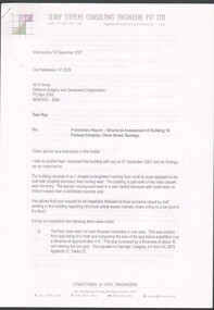
Document - Preliminary report of Structural assessment Fortuna
... by Structural Engineers - Terry Stevens Consulting Engineers Pty Ltd..... Prepared for DIGO by Structural Engineers - Terry Stevens ...Fortuna Villa was initially commenced as a modest single storey home in 1861 next to the 180 Mine by Theodore Ballerstedt, who sold the mine and house to George Lansell in 1869. Lansell already owned the adjacent Fortuna Mine, and through deeper mining techniques greatly expanded the mine's operation, his personal wealth, and the house and grounds. Lansell was soon known as the 'Quartz King', Australia's first gold mining millionaire and credited as the driving force behind much of Bendigo's prosperity. He continuously added to and expanded the villa, decorating it extravagantly with the finest of artworks and materials, into a sprawling mansion with extensive landscaped grounds, to create a house and grounds of a size and grandeur with few rivals in Australia. After his death in 1907, his second wife Edith carried on with improvements, creating a house and grounds developed over 50 years. The attached mine also contributes to its significance, being one of the richest mines in Bendigo, and at one stage probably the deepest gold mine in the world at 3176 feet. The 1875 crushing works are attached directly to the mansion, and the mine's tailings and settling ponds (turned into ornamental lakes) represent a direct link between George Lansell's wealth and its source. Fortuna was compulsorily acquired by the Commonwealth in 1942 as the Cartographic Headquarters of the Australian Survey Corps during World War II, and many ancillary structures were added while preserving the main house and ornamental grounds. Victorian Heritage Database Report https://vhd.heritagecouncil.vic.gov.au/places/68334/download-reportPreliminary report of Structural assessment of Building 16 Fortuna Complex, Chum Street, Bendigo. Four page preliminary report finding the building is structurally safe as at Wed 19 December 2007 with three recommendations. Prepared for DIGO by Structural Engineers - Terry Stevens Consulting Engineers Pty Ltd.fortuna, structural assessment -
 Federation University Historical Collection
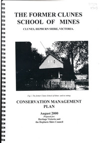
Book, The Former School of Mines Clunes Conservation Management Plan, 2000, 08/2000
... information, structural engineers Report, Department of Lands Survey... and keeping information, structural engineers Report, Department ...The Clunes School of Mines was a campus of the Ballarat School of Mines. The conservation plan was prepared for Hepburn Shire Council and Heritage Victoria to guide the future management of the former Clunes School of Mines in Service Street, Clunes, The building was opened in February 1892 as the Clunes branch of the Ballarat School of Mines, and ceased operating in June 1893.Spiral bound black and white copy of the Conservation Plan for the Clunes School of Mines. Contents include the history, chronology development, context of the building and site, current and past function of the building, original fabric, impact of later alterations, condition of the building, statement of significance, conservation action plan, caring for the site, collecting and keeping information, structural engineers Report, Department of Lands Survey 1955, Memorandum of Agreement 1956.ballarat school of mines, clunes school of mines, australian native association, ana, australian native association clunes branch, eygelaar inner spring mattress factory, clunes infant welfare centre, clunes angling club -
 Kiewa Valley Historical Society
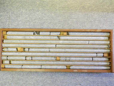
Core Rock Samples
... out (under the control of design and structural engineers... and structural engineers of the SEC Kiewa Hydro Scheme - late 1940's ...The core samples in the display cabinet were obtained from the various sites at which drilling into the rock surface was carried out (under the control of design and structural engineers of the SEC Kiewa Hydro Scheme - late 1940's). This function was a precursor to the decision where to locate, in this case, the McKay Creek Power Station. The information gained by structural engineers from the core samples would be used also for the placements of underground tunnels entry and exit points and the overall effective size of the generator plant. This would have included drill and blast techniques (rock characteristics play an import part of explosion control), requirements for support structures and reinforcing cement/steel forms. The use and replenishment of diamond drill bits(the strongest available, see KVHS 0280) was dependent on the "type" of rock found (harder rock required greater numbers of drill bits). Support beams for reinforced ceilings and floors was also a necessity.These rock core samples are very significant in the formulation and placement of the underground Power Stations and their maze of tunnels (in and out) for a successful implementation of the Hydro Scheme. The amount of pre-planning and engineering studies required for such a large scheme must be undertaken to ensure that a "white elephant" was not the result.There are nine columns of rock cores, each 30mm in diameter, set in a wooden display rack. A clear plastic (slide out) protective panel is installed to the front section. Within each column are block details of the depth from which that section was brought from. See KVHS for the appropriate sketch details.Depth levels (retrieved from) are shown for each section on wooden Blocks: 1st Block: "7'10" (seven feet, ten inches), 2nd Block:"9'4" (nine feet, four inches), 3rd Block: "19'3" (nineteen feet, three inches), 4th Block: "24'2" (twenty four feet, two inches), 5th Block: "25'7"( twenty five feet, seven inches) and last block: "30' (thirty feet)"alternate energy supplies, alpine feasibility studies temperature, rainfall, sec, kiewa hydro scheme, electricity -
Clunes Museum
Document
... STAPLED REPORT BY CONSULTING ENGINEERS ,SURVEYORS...DOCUMENT Document STAPLED REPORT BY CONSULTING ENGINEERS ...STAPLED REPORT BY CONSULTING ENGINEERS ,SURVEYORS STRUCTURAL REPORT - CLUNES MUSEUM 7 SEPTEMBER 1998local history, document, structual appraisal, structual appraisel -
 Warrnambool and District Historical Society Inc.
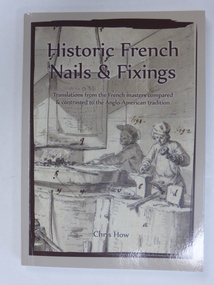
Book, Historic French Nails and Fixings, 2017
... by Chris How, a retired Civil/Structural Engineer who lives..., a retired Civil/Structural Engineer who lives in Warrnambool ...This book contains information on historic French nails and fixings, being translations from the French Masters compared and contrasted to the Anglo-American tradition. It has been compiled by Chris How, a retired Civil/Structural Engineer who lives in Warrnambool, Victoria. He has been involved with conservation and heritage buildings for half a century and it was working with pioneer materials and techniques that first stimulated his interest in historic nails. He has completed a Master’s degree in England and made a special study of French and Germanic framing and its spread across Europe. This involved similar studies in Denmark, Belgium, the Baltic countries and Australia. This book is of interest because it was written by a local Warrnambool resident, one who has researched and studied many buildings in Warrnambool and district through an examination of the building materials used, especially the nails and fixings. This is a soft cover book of 126 pages The cover is grey with a grey, black and white sketch on the front cover and a colour photograph on the back page. The book has contents pages, a list of tables and figures, a list of the source of illustrations and credits, a foreword, acknowledgements, a preface, eight chapters, a glossary of terms and appendices. There are many black and white and colour illustrations. chris how, history of nails, history of warrnambool -
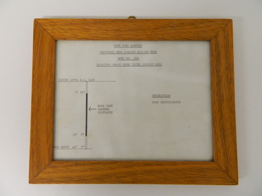 Kiewa Valley Historical Society
Sketch Rock Core Display, circa mid to late 1900's
... Creek Power Station. The information gained by structural... Station. The information gained by structural engineers from ...This framed sketch details, in graphic form, where the core samples in the display cabinet were removed. The drilling was a precursor to the decision where to locate, in this case, the McKay Creek Power Station. The information gained by structural engineers from the core samples would be used also for the placements of underground tunnels entry and exit points and the overall effective size of the plant. This would have included drill and blast techniques(rock characteristics play an import part of explosion control), requirements for support structures and reinforcing cement/steel forms. The use and replenishment of diamond drill bits(the strongest available, see KVHS 0280) was dependent on the "type" of rock found. Support beams for reinforced ceilings and floors was also a necessity.The visual derails of where the rock core samples were removed is very significant in the formulation and placement of the underground Power Stations and their maze of tunnels(in and out) for a successful implementation of the Hydro Scheme. The amount of pre-planning and scientific studies required for such a large scheme must be undertaken to ensure that a "white elephant" was not the result.This framed and glass front rock core display sketch has type written information of the rock samples displayed in KVHS 0279 (A). It has a softwood stained and glossed frame with a fixed(nailed) back board and a brass fixture for mounting onto a wall.The paper and type are slighted faded (sunlight affected). The sign heading "ROCK CORE SAMPLES RECOVERED FROM DIAMOND DRILLED BORE" underneath this "BORE NO: 883" and below this "LOCATION: McKAY CREEK POWER STATION AREA" to the left a sketch incorporating the ground level point "GROUND LEVEL R.L.3493", and the core depth point "CORE DEPTH 40' 7". In between and representing( in visual form) the core location areain question.alternate energy supplies, alpine feasibility studies temperature, rainfall, sec, kiewa hydro scheme, electricity -
 Robin Boyd Foundation
Drawing - Architectural, 290 Walsh Street, South Yarra, Apr-58
... of Alan J Brown - Surveyor and Engineer. Structural details... Structural Details, Colour Photocopy Project: House for Mr and Mrs ...Project: House for Mr and Mrs Robin Boyd drawn by JJJS of Alan J Brown - Surveyor and Engineer. Structural details drawings 1437-1Structural Details, Colour Photocopy -
 Robin Boyd Foundation
Drawing - Architectural, 290 Walsh St South Yarra, Apr-58
... of Alan J Brown surveyor and engineer. Structural details drawings... drawn by J.J.J.S of Alan J Brown surveyor and engineer ...Project: House for Mr and Mrs Robin Boyd drawn by J.J.J.S of Alan J Brown surveyor and engineer. Structural details drawings 1437-2Working drawing, Colour photocopy -
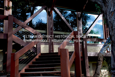
 Eltham District Historical Society Inc
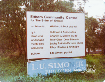
Photograph, Peter Bassett-Smith, Construction of Eltham Community Centre, June 1977, 1977
... Pty Ltd; Quantity Surveyor: D.J. Cant & Associates; Structural... Pty Ltd; Quantity Surveyor: D.J. Cant & Associates; Structural ...Building construction sign - Architects: Whitford & Peck Pty Ltd; Quantity Surveyor: D.J. Cant & Associates; Structural Civil Engineers: Charlett & Moore Pty Ltd; Landscape: Peter Glass, Dennis Edwards; Mech Elec: Lobley Treidel & Partners Pty Ltd; Acoustics: Riley Barden & Kirkhope; Builder: L.U. Simon Pty Ltdeltham, eltham community centre, buildings, construction -
 Eltham District Historical Society Inc
Photograph - Digital Photograph, Jim Connor, Eltham Community and Reception Centre, 801 Main Road, Eltham, 9 July 2008
... Quantity Surveyor: D.J. Cant & Associates Structural Civil... Quantity Surveyor: D.J. Cant & Associates Structural Civil ...The Eltham Community and Reception Centre was Australia's first public mud-brick building. Commissioned in 1977 by Eltham Shire Council, led by Shire president (and architect) Robert Marshall, architects Whitford and Peck were asked to design a multipurpose facility in mud-brick and timber. The official opening was performed by the Hon. R.J. Hamer; E.D., M.P., Premier of Victorai on Saturday, April 22, 1978. Architects: Whitford & Peck Pty Ltd Quantity Surveyor: D.J. Cant & Associates Structural Civil Engineers: Charlett & Moore Pty Ltd Landscape: Peter Glass, Dennis Edwards Mech Elec: Lobley Treidel & Partners Pty Ltd Acoustics: Riley Barden & Kirkhope Builder: L.U. Simon Pty Ltdjim connor collection, eltham community and reception centre, eltham community centre, mudbrick construction -
 Eltham District Historical Society Inc
Photograph - Digital Photograph, Marguerite Marshall, Eltham Community and Reception Centre, 2 October 2006
... Quantity Surveyor: D.J. Cant & Associates Structural Civil... Structural Civil Engineers: Charlett & Moore Pty Ltd Landscape: Peter ...The Eltham Community and Reception Centre was Australia's first public mud-brick building. Commissioned in 1977 by Eltham Shire Council, led by Shire president (and architect) Robert Marshall, architects Whitford and Peck were asked to design a multipurpose facility in mud-brick and timber. The official opening was performed by the Hon. R.J. Hamer; E.D., M.P., Premier of Victorai on Saturday, April 22, 1978. Architects: Whitford & Peck Pty Ltd Quantity Surveyor: D.J. Cant & Associates Structural Civil Engineers: Charlett & Moore Pty Ltd Landscape: Peter Glass, Dennis Edwards Mech Elec: Lobley Treidel & Partners Pty Ltd Acoustics: Riley Barden & Kirkhope Builder: L.U. Simon Pty Ltd Covered under Heritage Overlay, Nillumbik Planning Scheme. Published: Nillumbik Now and Then / Marguerite Marshall 2008; photographs Alan King with Marguerite Marshall.; p177This collection of almost 130 photos about places and people within the Shire of Nillumbik, an urban and rural municipality in Melbourne's north, contributes to an understanding of the history of the Shire. Published in 2008 immediately prior to the Black Saturday bushfires of February 7, 2009, it documents sites that were impacted, and in some cases destroyed by the fires. It includes photographs taken especially for the publication, creating a unique time capsule representing the Shire in the early 21st century. It remains the most recent comprehenesive publication devoted to the Shire's history connecting local residents to the past. nillumbik now and then (marshall-king) collection, eltham community and reception centre, mudbrick construction -
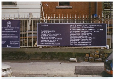 Queen Victoria Women's Centre
Photograph, c.1995/1996
... . Structural/Civil Engineer: John Mulle and Partners Pty. Ltd... (Vic) Pty. Ltd. Structural/Civil Engineer: John Mulle ...Colour photograph. The board which was outside the QVWC building's gates on Lonsdale street. which details main groups involved in refurbishment of the building. "Principle: Office of Women's Affairs - Department of Justice. Principle Agent - Office of Building. Refurbishment Project Team. Project manager: Atkinson Project Management (Aust.) Pty. Ltd. Architects: Robert Peck won Hartel Trethowan. Conservation Architect: Meredith Gould Architects Pty. Ltd. Quantity Surveyor: Rawlinsons (Aust.) Pty. Ltd. Services Engineer: Addicoat Hogarth WIlson (Vic) Pty. Ltd. Structural/Civil Engineer: John Mulle and Partners Pty. Ltd. Landscape Architect: Elizabeth Peck, Landscape Architect. Building Certifier: Philip Chun and Associates (Vic.) Construction Manager: Kane Constructions (Vic.) Pty. Ltd."historic buildings, building construction -
 Federation University Historical Collection
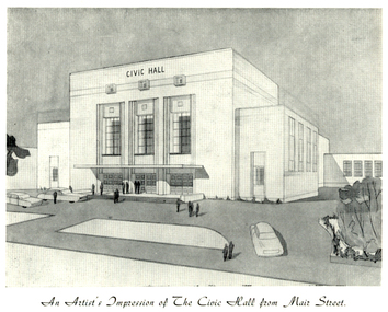
Programme, The Opening of Civic Hall, 1956
The City of Ballarat unanimously resolved to erect a Civic Hall in Mair Street in 1951. The architects, Gordon Murphy, of Melbourne, and H.L. and L.J. Coburn, of Ballarat, were commissioned in 1952. The Council constructed the foundations and footings for the building under the supervision of the former City engineer, Mr L.H. Finch, in 1953. These footings are of massed concrete. The design for the building took advantage of the cross fall of the land, providing for the Small Hall to be entered from the Doveton Street frontage through a foyer under the Main Stage, the structure is steel with brick panels, with accommodation for 1,592 persons in the Main Hall and 440 persons in the Lower Hall. The front facade faces Mair Street, set back from the building line to provide for the entrance drive-ways and kerbed gardens. Tenders were invited on a firm price basis. A young Ballarat master Builter, Walter Benbow Trahar was the successful tenderer, the contract price being 139,841 pounds. the work was commenced in 1953 and has proceeded in spite of material and labour difficulties until its completion. The following statistics are of interest:- * The foundations contained 200 cubic yards of concrete. * The constructional steel work weighs approximately 270 tons. * The reinforcing steel 47 tons. * Reinforced concrete in the structure, 1,100 cubic yards. * The approximate number of bricks in the building, 580,000. * The flooring is of selected kiln-dried hard wood and totals 40,000 lineal feet. * The dimensions of the Main Auditorium, 100ft by 86 ft, including the side promenades each 82ft by 13ft. *The Main stage, of reinforced concret with parquette finish measures 62 ft by 40ft. *The floor area of the Lower Hall is 74 ft by 38 ft, and has a stage dimensions of 40ft by 20 ft. * Each hall has independent heating and ventillating systems. Where possible the material in the building was furnished from local business houses. The public address installation, which provided for additional microphones, is on the main Stage. There is inter-communication throughout the building connecting the front office, with the bioscope box, the stages in both the large and lower halls, and the Hallkeeper's residence. Local craftsmen have completed the painting, plaster work, and the electrical installation; local produced materials being used in the construction of the buildings with the exception of the timber for the Main Floor, the roofing and the structural steel. The City of Ballarat Councillors in 1956 were Councillors N. T. Callow, F.J. Cutts, K.C. Webb, W.E. Roff, O.W. Curnow, F.T. Woodward, Allan C. Pittard, A.W. Nicholson, J.A. Chisholm, G.L. Scott, F.W. Oliver, A.D. Mason. The Town clerk was H.R. Maddern and the City Engineer was G. Murrowood. A City of Ballarat Council meeting of 25 September 2013 voted to demolish the Ballarat Civic Hall. The Council heard from nearly 50 members of the public during a marathon six-hour meeting. Councilors John Birt, Des Hudson, Amy Johnson, Josh Morris, Peter Innes, John Philips supported the motion to demolish Civic Hall. Councillors Samantha McIntosh, Vicki Coltman and Belinda Coates voted against the motion.Six page souvenir Program of citizens' entertainment on the occasion of the Opening of Ballarat Civic Hall on in August 1956. The front cover features the City of Ballarat Coat of Arms. The programme starts with a message from the Mayor, Cr Neil T. Carrow. It includes the Concert Programme directed by James H. Davey, an asrtist's impression of the Civic Hall from Mair Street, and information relative to the New Civic Hall. The programme features images of the City of Ballarat Coat of Arms, Cr N.T. Callow, , James H, Davey, and an artist's impression of the Ballarat Civic Hall. Mayor Neil Callow's Message: "To-day, our citizens witness the fulfilment of the most extensive Municipal undertaking in the City's period of recent prosperity and development. Their Hall now fills a requirement of which they have been deprived since the Coliseum building was destroyed by fire over 20 years ago. The building has been designed as an all purpose structure and I am hopeful the citizens will use it and enjoy it to its fullest extent. Your Council and its Architects have planned as broadly as possible for the benefit of all to-day and for years to come. We are proud of the work executed by a Ballaarat Master Builder whose work is a monument to the City's craftsmen. I feel I should also remind this assembly that the women of Ballaarat, back in 1951, provided funds which have been applied in the purchase of a Grand Piano and two Upright Pianos which are now installed in this building. The sincere hope of myself and your Councillors is that this Hall and its amenities will prove of immense value to the development of the cultural and artistic tastes of this community and that it will be freely used for these and many other purposes. From now on this magnificent building and its furnishings and equipment will be available to all. I strongly exhort you to use and protect it. My hope is that the citizens will, for many years to come, enjoy the amenities which it has to offer. ballarat civic hall, civic hall, architecture, finch, art deco, city of ballarat, coat of arms, city of ballarat coat of arms, callow, shugg, lemke, oates, gullan, tuuri, john, robertson, sorrell, antonio, gordon murphy, walter benbow trahar, trahar, coburn, h.l. coburn, l.j. coburn, n.t. callow -
 Kiewa Valley Historical Society
Drill Bit Diamond, circa mid to late 1900's
... and structural engineers. It was only after extensive core drilling ...This hollow core bit has hard cutting inserts for drilling into rock. It was used to drill and recover 50mm diameter (most common size) rock cores. The rock cores were assessed by geologists and engineers to provide information for design of structures such as tunnels, dams and underground power stations (eg. McKay Creek Power Station, West Kiewa Power Station). This type of bit was also used where damage to the surrounding rock had to be minimised. The Diamond Drill Bit,used in the early 1900's, when it was primarily used as a method of sampling rock for ore deposits and oil exploration resulting in a "coring" of rock. The use of "coring" to obtained samples for the SEC Kiewa Hydro Electricity Scheme(1920's onward) was to analyse the core to obtain temperature and rainfall patterns shown by the levels of layered solidified soil(rock). This diamond drill would have been used in the early 1900's to provide a sub strata map of temperature and water patterns (over an long period of time). This was a pre requisite to any decisions about the viability of the region to provide the water needed for a successful hydro electricity scheme.This diamond drill for core sampling was at the forefront of the analysis whether to construct a hydro electrical facility in the Kiewa Valley and the adjoining alpine region. The rock core samples produced were assessed by geologists and structural engineers. It was only after extensive core drilling covering the region that solid scientific evidence could be provided to start the "SEC Vic Hydro Electricity Scheme" within its current boundaries.This "diamond" drill bit has eight "teeth" at its cutting edge. The drill creates an 55mm hole in extremely hard rock material to obtain 50mm core samples.. Three quarters down the shank it has thread screw channels to attach the bit to the drill pipe. The coring pipe attaches via screwing it onto this bit. Core samples are the main objective of this tool.alternate energy supplies, alpine feasibility studies temperature, rainfall, sec, kiewa hydro electric scheme, electricity -
 The Beechworth Burke Museum
Photograph, 1960s
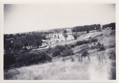
This photograph was taken in the 1960s at Lake Sambell and is a view across the lake from the east side, the photo was taken during a period of improvements to the lake and surrounding area. Lake Sambell is an artificial lake that was created on the site of the old Rocky Mountain Mining Company workings and was officially opened by Minister for Lands, Mr Baily, on October 5, 1928. The disused and unattractive remains of the mine were converted into a recreational area intended for swimming, boating, and fishing. The lake is named after Mr L.H. Sambell, shire engineer and secretary of the Forward Beechworth Committee, who advocated for the enhancement of Beechworth into a tourist destination and was central to the planning and establishment of the lake. Funding for the project was raised through both competition funds and donations. Since the construction in 1928 several engineering issues have arisen. In 1939 the water levels were low, and the lake was considered both an eyesore and ‘mudhole’, Beechworth Shire Council sort funding to raise the height of the lake six feet to improve the quality of water. Throughout the 1940s the Beechworth Swimming Club sort to address the structural engineering issues and improve swimming facilities at the lake. R.E. Carter, similar to L.H. Sambell, was a shire engineer who advocated the importance of positioning Beechworth as a tourist destination. Carter held the position of shire engineer from 1954-63 and organised many improvements to the Lake Sambell area including the caravan park in 1959, the lake swimming pool in 1961, water skiing and boating facilities, and increased the lake surface area in 1964. These improvements to the lake also reflect an increase in leisure time and access to travel during a period of post-war prosperity in Australia during the 1950s and 60s. This photograph is of historical significance as it documents Lake Sambell in the 1960s after a series of enhancements to the lake area to improve its appearance and usability for both the people of Beechworth and tourists. It is also of social significance in providing an insight into the increase in leisure time and access to travel during a period of post-war prosperity. Black and white rectangle photograph printed on photographic paper and unmounted.Reverse: 3534 C798lake sambell, l.h. sambell, r.e. carter, rocky mountain mining company, forward beechworth committee, beechworth swimming club, wallace park lake sambell development scheme, lake sambell caravan park, beechworth 1960s, lake sambell swimming pool, lake sambell boating, lake sambell fishing, swimming, boating, water skiing, fishing, post-war prosperity, minister of lands, artificial lake, open cut sluice mine, lake -
 The Beechworth Burke Museum
Photograph, 1960s
This photo was taken in the 1960s from a northeast position looking down towards Lake Sambell, the caravan park, and the surrounding area. This photo was taken during a period of rejuvenation for the lake area including the opening of the caravan park in 1959 and the swimming pool area in 1961 (this pool is just visible in the centre of the photo). The popularity of caravanning in Australia exploded during this post-war period of the late 1950s and 1960’s. This popularity was driven by multiple factors, including: the stopping of fuel rations, the accessibility of car ownership through the manufacturing of affordable cars, technological developments in caravan design, and the increase in prosperity and leisure time for many Australians. Lake Sambell is an artificial lake that was developed on the previous site of the Rocky Mountain Mining Company workings and was officially opened by Minister for Lands, Mr Baily, on October 5, 1928. The disused and unattractive remains of the mine were converted into a recreational area intended for swimming, boating, and fishing. The lake is named after Mr L.H. Sambell, shire engineer and secretary of the Forward Beechworth Committee, who advocated for the enhancement of Beechworth into a tourist destination and was central to the planning and establishment of the lake. Funding for the project was raised by both competition funds and donations. Since the construction in 1928 several engineering issues have arisen. In 1939 the water levels were low, and the lake was considered both an eyesore and ‘mudhole’, Beechworth Shire Council sort funding to raise the height of the lake six feet to improve the quality of water. Throughout the 1940s the Beechworth Swimming Club tried to raise awareness and funds to address the structural engineering issues and improve swimming facilities at the lake. R.E. Carter, similar to L.H. Sambell, was a shire engineer who advocated the importance of positioning Beechworth as a tourist destination. Carter held the position from 1954-63 and organised many improvements to the Lake Sambell area including the caravan park in 1959, the lake swimming pool in 1961, water skiing and boating facilities, and increased the lake surface are in 1964. These improvements were financed mainly by grants from the Tourist Development Authority. This photograph is of historical significance as it documents Lake Sambell and the surrounding area in the 1960s after a phase of enhancements to improve the appearance and usability for both the people of Beechworth and tourists. It is also of social significance in providing an insight into the increase in leisure time and access to travel during a period of post-war prosperity.Black and white rectangle photograph printed on matte photographic paper and unmounted.Reverse: 1 / [logo KODAK/ VELOX/ PAPER] / C798 / 3535lake sambell, lake sambell caravan park, lake sambell swimming pool, caravan park, caravanning 1960s, rocky mountain mining company, l.h. sambell, r.e. carter, beechworth swimming club, forward beechworth committee, minister of lands, tourist development authority, lake swimming, swimming, boating, fishing, water skiing, beechworth 1960s, lake sambell fishing, lake sambell boating -
 Robin Boyd Foundation
Document - Manuscript, Robin Boyd, Under Tension, 1963
Boyd argues that modern architecture has triggered a necessity for greater harmony between architects and engineers. Boyd describes the architectural qualities of tension structures through an analysis of several case studies including projects by Frei Otto and Boyd's own house at Walsh St. Being a relatively new concept, Boyd criticises the neglect towards smaller buildings in this structural system, and also highlights some of its shortcomings. A 2-page letter from 'Arthur' (surname unknown) at the University of Melbourne's Department of Civil Engineering provides feedback to Boyd on his analyses of the chosen case studies.Original manuscript of article published in The Architectural Review Vol.134, No.801, November 1963, pp. 324 - 334. This draft was returned with covering letter from: ‘Arthur’ (AJF) Melbourne Uni. Dept Civil Engineering. Typewritten (c copy), foolscap, 14 (+2 quarto letter) pagesMinor handwritten editsengineering, tensile structure, master-designer, bernard lafaille, zagreb french pavilion, matthew nowicki, livestock pavilion, frei otto, paul rudolph, florida house, bill irwin, kevin borland, peter mcintyre, john and phyllis murphy, yuncken freeman, sidney myer music bowl, eero saarinen, yale hockey rink, edward d. stone, brussels u.s. fair pavilion, boston arts centre, walsh street, robin boyd, manuscript -
 Australian Gliding Museum
Machine - Glider – Sailplane, 1972
The Hall Cherokee II glider is an American design for amateur construction from plans. The designer was Stan Hall (1915-2009), a professional engineer, who gained extensive experience in the United States aviation industry during World War 2 including the programs for military gliders. He continued to work as an engineer for aircraft manufacturers and as a consultant to the industry after the war. He was active in gliding and, in particular, the home built sailplane movement. The Cherokee II was one of about 10 glider designs that he produced: it came out in 1956. It is understood that over 100 Cherokee gliders have been built. In Australia the number is possibly 10 or 11. The Hall Cherokee VH-GVO was built by R.D Meares of Caringbah, New South Wales. The glider was registered as VH-GVO on 11 October 1973 and given serial number “GFA-HB-82” by the Gliding Federation of Australia. The Logbook for VH-GVO appears to be a complete record of the flying history; in aggregate 210 hours 40 minutes in the air from 331 flights. The first test hop occurred on 29 July 1972 at Camden, New South Wales. VH-GVO was last flown on 22 July 1986. Many of the flights recorded are of one or two hours duration. The glider was last inspected and certified as airworthy and in a reasonable condition at the Hunter Valley Gliding Club in July 1986. Since that time, until transferred to the Australian Gliding Museum, the glider was in storage. Structural restoration work has been completed on the fuselage and one wing. However, inspection of the other wing revealed extensive damage to the ribs and spars and consequently a decision was taken to make it a static exhibit. The exhibit is an example of home built construction of a type that has proved popular amongst amateur glider builders.The Hall Cherokee (formerly registered as VH-GVO) is a single seat wooden home built glider. The glider is constructed from wood, plywood, fabric and metal fittings, all commercial grade except for main wing fittings, pulleys, cables and bolts. The fuselage is simple with four main longerons and bulkheads with diagonal bracing. The wing has two identical solid spars which form a geodetic structure, hence the leading edge is non-structural. Registration VH-GVO – serial number GFA-HB-82 australian gliding, glider, sailplane, hall, cherokee, meares, hunter valley gliding club -
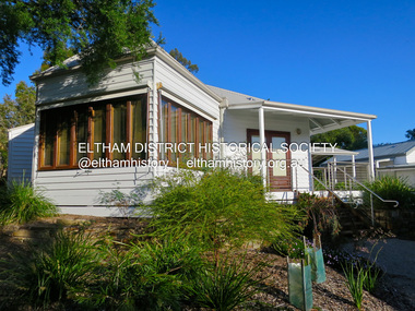
 Eltham District Historical Society Inc
Photograph - Digital Photograph, Alan King, Eltham Living and Learning Centre, 26 January 2008
In 1857, tanner John Pearson purchased three and a half acres of land in Little Eltham, at the western end of Pitt Street, with a 70-foot frontage to Maria Street (Main Road) and stretching down to the Diamond Creek for £100. He contracted Benjamin Oliver Wallis to build house for him. Wallis, a mason by trade who originated from the Cornish village of Newlyn, migrated to Melbourne in 1853 and was shortly engaged by Richard Warren to build the Eltham Hotel, which opened in 1854. When Warren fell into financial difficulty in 1858, Wallis purchased the hotel. That same year, Pearson constructed a tannery below the house with access to the water in the Diamond Creek. When Pearson became bankrupt in 1867, Wallis similarly acquired the house from Pearson’s creditors in 1868 and lived there until his death in 1896. For some of this time the house was in the name of Wallis’s son Richard but following his death in 1888, ownership reverted to his father. It was purchased by retired teacher Richard Gilsenen in 1899. Gilsenen was made acting head teacher at the Eltham State School in 1906 following the sudden death of head teacher John Brown. In the 1950s the house was bought by retired engineer Dr Alfred Fitzpatrick and his wife Claire who made various modifications to house goats and poultry as well as structural modifications to the house. In the early 1970s, Eltham Shire Councillors Frank Maas and Don Maling proposed an extended communities’ activities program be set up and the Commonwealth Grants Commission was approached for financial assistance. In 1974 a $50,000 Commonwealth Grant was received by the Shire Council to acquire the Fitzpatrick property as part of the planning to establish an extended communities’ activities program. The Fitzpatricks moved next door and Claire taught at the new Living and Learning Centre, which began in 1975, one of the first community education centres in Victoria. Covered under Heritage Overlay, Nillumbik Planning Scheme. Published: Nillumbik Now and Then / Marguerite Marshall 2008; photographs Alan King with Marguerite Marshall.; p59This collection of almost 130 photos about places and people within the Shire of Nillumbik, an urban and rural municipality in Melbourne's north, contributes to an understanding of the history of the Shire. Published in 2008 immediately prior to the Black Saturday bushfires of February 7, 2009, it documents sites that were impacted, and in some cases destroyed by the fires. It includes photographs taken especially for the publication, creating a unique time capsule representing the Shire in the early 21st century. It remains the most recent comprehenesive publication devoted to the Shire's history connecting local residents to the past. nillumbik now and then (marshall-king) collection, benjamin oliver wallis, claire fitzpatrick, don maling, dr alfred fitzpatrick, eltham living and learning centre, frank maas, john pearson, richard gilsenen, tannery -
 Harcourt Valley Heritage & Tourist Centre
postcard, A N A Hall, Harcourt, 1915
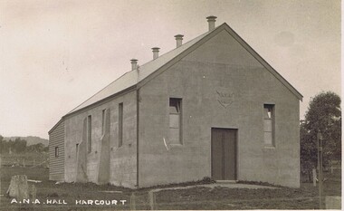
Harcourt branch of the Australian Natives Association was formed in 1908, meeting in a chaff shed behind the local grocer shop. In 1911 the branch contracted with Mr Sutherland of Barkers Creek to build a hall of boxed concrete construction. Sutherland was a pioneer in the use of concrete for structural purposes.He subsequently had a career as City Engineer at Camberwell. The ANA branch conducted many social occasions in the hall and gave community leadership for upwards of fifty years in addition to its friendly society/health insurance activities.. This was the only community hall in the Harcourt community until it was superseded by the Harcourt Leisure Centre in 1991 It is now the home of Harcourt Heritage Centre.A community hall of pioneering construction method, provided to the community by a friendly society.black and white postcard depicting a community hallA N A Hall, Harcourt -
 Eltham District Historical Society Inc
Photograph - Digital Photograph, Jim Connor, The Pavillion, Eltham Living and Learning Centre, 739 Main Road, Eltham, 29 November 2016
The Pavillion was an extension to the Eltham Living and Learning Centre which was opened 8 October, 1994 In 1857, tanner John Pearson purchased three and a half acres of land in Little Eltham, at the western end of Pitt Street, with a 70-foot frontage to Maria Street (Main Road) and stretching down to the Diamond Creek for £100. He contracted Benjamin Oliver Wallis to build house for him. Wallis, a mason by trade who originated from the Cornish village of Newlyn, migrated to Melbourne in 1853 and was shortly engaged by Richard Warren to build the Eltham Hotel, which opened in 1854. When Warren fell into financial difficulty in 1858, Wallis purchased the hotel. That same year, Pearson constructed a tannery below the house with access to the water in the Diamond Creek. When Pearson became bankrupt in 1867, Wallis similarly acquired the house from Pearson’s creditors in 1868 and lived there until his death in 1896. For some of this time the house was in the name of Wallis’s son Richard but following his death in 1888, ownership reverted to his father. It was purchased by retired teacher Richard Gilsenen in 1899. Gilsenen was made acting head teacher at the Eltham State School in 1906 following the sudden death of head teacher John Brown. In the 1950s the house was bought by retired engineer Dr Alfred Fitzpatrick and his wife Claire who made various modifications to house goats and poultry as well as structural modifications to the house. In the early 1970s, Eltham Shire Councillors Frank Maas and Don Maling proposed an extended communities’ activities program be set up and the Commonwealth Grants Commission was approached for financial assistance. In 1974 a $50,000 Commonwealth Grant was received by the Shire Council to acquire the Fitzpatrick property as part of the planning to establish an extended communities’ activities program. The Fitzpatricks moved next door and Claire taught at the new Living and Learning Centre, which began in 1975, one of the first community education centres in Victoria.jim connor collection, eltham, eltham living and learning centre, living and learning centre, pavilion